Welcome to the Town of Rockville, Utah
Rockville Utah
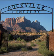
Nestled in the canyon of the Virgin River, under the watchful eye of towering peaks and cliffs, lies the Town of Rockville – a rural residential and agricultural community whose current population numbers only 274. Since its founding by Mormon pioneers in 1862, Rockville has worked to maintain the vision of its forefathers. Annual events, volunteer projects, and neighbors helping neighbors bring residents together to strengthen the sense of community.
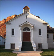
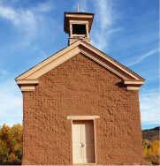
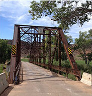
As you pass through on your way to or from Zion National Park, slow down and enjoy the peaceful beauty of this small town – its towering trees and open fields, its historic bridge, buildings, and stone irrigation ditches. Historians have referred to Rockville as “the last treasure in Utah”. Its residents would agree!


News & Information
- Tree City 2023
- Rockville Town Variance Hearing
- Hoary Cress (Whitetop) Notice
- Virgin River Harmful Algae Blooms - Update 5/30/2023
- National Flood Insurance Program
- Removing Tamarisk & Russian Olive
- Utah Geological Survey
Variance Hearing Officer
Town of Rockville
Rockville Community Center, Town Hall
February 12, 2024 – 5:30 pm
The Variance Hearing Officer for the Town of Rockville will hold a Variance Hearing on Monday the 12th day of February 2024 at 5:30 p.m. in the Rockville Community Center Town Hall, 43 E. Main, Rockville, Utah.
The agenda will be as follows:
- Call to Order
- Request from A. Jacob Andersen for a Variance from the terms of the Rockville Land Use Code relevant to property identified by Rockville Parcel No. R-1304. The applicant requests that a variance be granted from setback requirements to construct a residential building upon the property. The applicant seeks to vary the following setback requirements: (1) the 50-foot setback from slopes in excess of thirty percent (30%) and (2) setback from high-hazard geological areas as required by the Sensitive Lands Regulations in Section 8.20.3.1.2 and (3) the setback requirements for lot standards in a RA-5 zone as described in 816.2.
- Adjourn
Vicki S. Bell
Town Clerk
THE PUBLIC IS INVITED TO PARTICIPATE IN ALL TOWN MEETINGS. If you need a special accommodation to participate in Town Meetings, please call the Town Clerk, Vicki S. Bell, at 772-0992 at least 24 hours prior to the meeting time.
Posted 2/2/2024
Public Notice — March 2023
Hoary Cress (Whitetop) Notice
Washington County Community Members:
Hoary Cress, commonly called Whitetop, is a class III noxious weed in the state of Utah and requires containment. We wanted to bring it to your attention that it has been found in communities throughout Washington County. We are requesting your assistance in controlling this weed. This is a perennial weed that is very invasive as it spreads through seed and creeping rootstocks called rhizomes. Hand pulling, digging, tilling, and mowing/cutting are not suggested as alternative treatments for Hoary Cress due to its spreading characteristics. Below you will find photos to help you identify Hoary Cress as well as chemical options to treat it:
1. Photos (shown in stages of growth):


2. Chemical Management
- Herbicide treatment should take place in spring when plants are actively growing, preferably at the full flowering stage of growth.
- Herbicide treatments can be made with:
- Glyphosate—Non-selective herbicide (will kill anything actively growing, including grasses).
- 2,4-D—Selective herbicide. Kills broadleaf plants but not grasses, if used.
- Metsulfuron Methyl (Escort XP or Telar XP)—Selective herbicide. Kills broadleaf plants, but not grasses, if used properly. Washington County Weed Control’s preferred choice of herbicide for spraying Hoary Cress and can be combined with 2,4-D.
- There are various other herbicides that can be used to treat Hoary Cress but are not utilized by the Washington County Weeds Department.
- Read chosen herbicide label for application rates. Some herbicide labels have specific instructions for Hoary
- A surfactant is recommended to be added to the herbicide spray mixture.
- After herbicide application, allow the area treated to sit undisturbed for a minimum of two
- All legal responsibility for herbicide application is the responsibility of the applicator. If you apply an herbicide, make sure you are not violating any laws and/or restriction specified on the label. If you have any questions regarding treatment of noxious weeds, please contact your local county noxious weeds department (contact info is listed on page 2) or The Utah State University Extension office.
3. Additional Information:
Complete control is not expected in one year’s time. For control/eradication of an infestation, it may take years of consecutive monitoring and treatments. In general, you should see a decrease of Hoary Cress every year of treatment and over time you might accomplish your goal of removal.
Thank you for your efforts in helping us manage Hoary Cress around Washington County. Additional noxious weeds will be popping up due to the additional moisture we have received this winter. See our website for more information on noxious weeds: https://www.washco.utah.gov/departments/noxious- weed-control/
Brad Winder
County Noxious Weeds Supervisor 111 East Tabernacle St.
St. George, UT 84770 Phone: (435) 634-5702
Brad.winder@washco.utah.gov
Benjamin Scow
Utah State University Extension – Washington County 339 South 5500 West
Hurricane, UT 84737
Office: (435) 634-5706
Benjamin.scow@usu.edu
Posted 03-01-2023
Here is the latest update on the Harmful Cyanobacteria Bloom Recreation Advisories for May 2023 Sampling:
Our tremendous winter has brought in scouring high runoff reducing benthic cyanobacteria loads in the major Virgin River tributaries of the park. As a result, Zion National Park will be downgrading the recreational health advisory to Health Watch for all waterbodies in the park. This change will take effect at 5 pm today when the Utah DEQ and Zion National Park websites below will be updated. Signs at major trailhead will be switched over in the next few days. Potential toxin-producing cyanobacteria is still present in some tributaries which are spring-fed and have low elevation watersheds, therefore visitors still need to remain vigilant for cyanobacteria when recreating in the park.
Zion National Park Harmful Algal Bloom Information Website
Utah DEQ Harmful Algal Bloom Information Website
Zion NP HCB Recreational Advisories:
North Fork of the Virgin River and flowing tributaries – Health Watch – avoid primary contact recreation
North Creek and flowing tributaries – Health Watch – avoid primary contact recreation
La Verkin Creek and flowing tributaries – Health Watch – avoid primary contact recreation
Robyn L. Henderek
Physical Scientist
Resource Management and Research Division
Zion National Park / Cedar Breaks National Monument / Pipe Spring National Monument
Posted 5/30/2023
Harmful Cyanobacteria Bloom (HCB) Update
Zion National Park continues to monitor monthly for the presence of harmful cyanobacteria and cyanotoxins. Zion staff take a “multiple lines of evidence” approach when using data to issue recreational advisories. Monitoring efforts have detected cyanotoxins harmful to humans and pets in the North Fork of the Virgin River, therefore, the North Fork of the Virgin River and all connected tributaries will be elevated to a Warning Advisory. A Health Watch remains in effect at La Verkin Creek and a Warning Advisory remains in effect at North Creek. During Warning and Health Watch advisories, recreators should avoid primary contact recreation such as swimming or submerging the head. Do not drink stream water anywhere in the park. Carry in water or filter directly from a spring source.
Toxin-producing cyanobacteria of the genera Microcoleus, Tychonema, and Nostoc have been found in the North Fork of the Virgin River, North Creek, and La Verkin Creek. Colonies of cyanobacteria can be yellow, tan, green, brown, or black in color. Toxins detected in Zion include anatoxin-a, nodularin, microcystin, and cylindrospermopsin.
Need to know about cyanobacteria
Children are especially vulnerable to cyanotoxins, so be mindful of where they go if you are near a body of water like the Virgin River.
- Do not swim or put your head under the water anywhere in Zion National Park.
- Keep dogs on a leash in and out of the water. Dogs are vulnerable to cyanotoxin exposure because they may bite or accidentally eat/drink material from potentially toxic algal mats. More information about the danger to dogs from toxic cyanobacteria.
- Do not drink any water from streams or rivers in Zion National Park. There is no known recreational water filtration method that is effective at removing cyanotoxins. If you must filter water for drinking while in the Wilderness, filter and disinfect it directly from a spring.
- Contact the Utah Poison Control Center at (800) 222-1222 with concerns about cyanotoxin poisoning and call 911 in the event of a medical emergency. Symptoms can include, but are not limited to, skin rash, salivation, drowsiness, tingling, burning, numbness, pain, incoherent speech, seizures, vomiting, and diarrhea.
- Some permitted activities, such as technical canyoneering, are allowed. Permits are still required. Check with the Wilderness Office at zion_park_information@nps.gov or 435-772-0170 for more information.
Learn more about toxic cyanobacteria from:
- Utah Department of Water Quality
- Utah Department of Health
- U.S. Environmental Protection Agency (EPA)
Updated 6/15/22
HOT OFF THE PRESS
Just released by FEMA the Risk Rating 2.0 Discount Guide-508c.
Posted 04/20/2022
_______________________________________________
Changes to the National Flood Insurance Program (NFIP).
Many Rockville homes fall within areas susceptible to flooding, either by our Virgin River or side drainages. In these areas flood insurance is likely required if you have a mortgage, or strongly recommended for those who own property free and clear.
Recent changes to the National Flood Insurance Program, aimed at spreading risk more equitably, are taking effect this year. In addition, the hoops and hurdles to get a policy have been significantly reduced. It’s likely that the average policy rate for fairly low risk areas like Rockville will decrease, while areas that see frequent flooding (think Florida) will see increased rates.
Below is a link to the NFIP as well as a link to a brief introductory video that describes the changes and process. Next step is to contact your insurance agent and make sure you’re covered and take advantage of the best rates possible.
| Title | Link | Video Description |
|
Risk Rating 2.0 – Equity in Action: FEMA’s New Rating Methodology
|
Video link: https://youtu.be/nxNO1k7J6qE | FEMA is committed to transforming the National Flood Insurance Program (NFIP) by leveraging industry best practices and current technology to better reflect a property’s individual flood risk. Insurance Agents can now access user-friendly technology that incorporates multiple flood risk factors and leverages a new rating methodology developed by the National Flood Insurance Program. Learn more about FEMA’s solution to simplify and improve the quoting process. |
Posted 2/23/2022
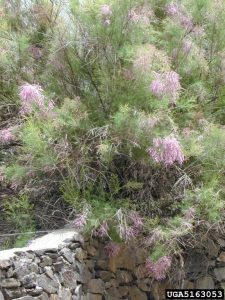
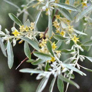
Invasive Russian Olive and Tamarisks
The Utah Division of Forestry, Fire, and State Land has obtained a grant to remove invasive Russian Olive and Tamarisks from Rockville in 2021. This is your opportunity to rid yourself of these invasive species at no cost to you!
This treatment is grant-funded, at no cost to the landowner (if they fall within the project boundary), and while funds are available one re-treatment will be conducted the following year. The treatment will be cutting Tamarisk and Russian Olive and spraying the stumps with herbicide immediately after to limit re-sprouting. Free landowner education is available as well.
To see if your property is eligible, please contact Carrie Howard, the Southwest Area Forester, at (435) 218-4629
or email:
carrielhoward@utah.gov
Tamarisk Russian Olive
UTAH GEOLOGICAL SURVEY

The Utah Geological Survey, (a division of the Utah Department of Natural Resources), has conducted an extensive investigation of the tragic rockfall that occurred in Rockville December 2009. The detailed report (and map) that identifies and addresses rockfall hazard areas in Rockville has been published and is available to Rockville residents and property owners electronically upon request at the Town Office.
Please note that the report and map gives an overall view of potential rockfall hazard areas and is not meant as a property or site-specific geologic study.
Contact Town Clerk Vicki S. Bell at (435) 772-0992 or by email at rockville@rockvilleutah.org if you would like the electronic report emailed to you. Hard copies will be made available for a fee of $10 by signing up at the Town Office. A hard copy is also available for review in the Town Office and the Springdale Library.
